We drove to Murrunrundi to see a park called the Eye of the Needle. An ambulance driver was nice enough to lead us in the direction of the road. But when we got to the last turn, we found road construction that prevented us from continuing. So we looked at the local Catholic Church and RR Station instead.
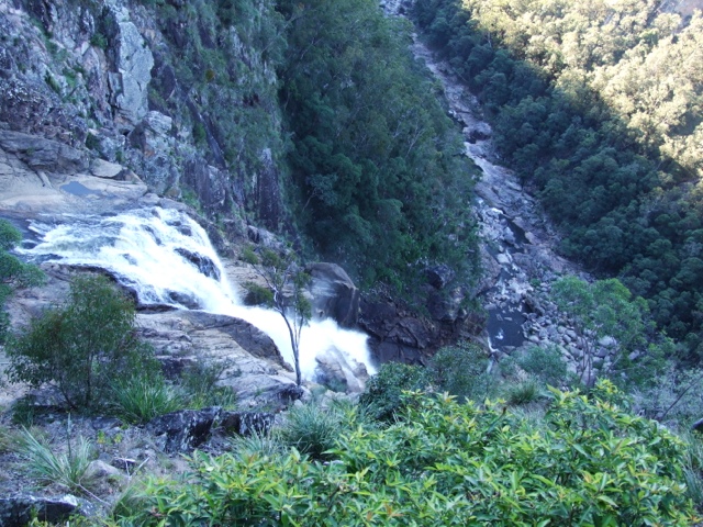
Down the road was a coal vein that has been burning for over 5000 years. We found the turnoff, but it would have taken over 2 hours to hike to it. We opted not to take the hike.
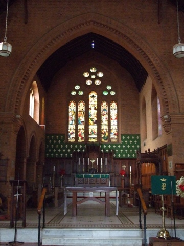
At Muswellbrook we went to St Alban's Church of England. It was closed but the secretary in the church office let us in. Another beautiful church. This one had painted wood ceilings and lovely stained glass windows. The town was also the home of the Blue Heeler, a cattle dog, a cross of dingoes with Northumberland Blue Merle's.
We spent the majority of the day driving. Outside of Tamworth we went through vast grasslands and cattle country. Then we drove through Scone, the premiere horse country in Australia, and past miles of horse farms. As we got closer to the coast, we went up and down long mountain roads and into an area of coal mining around Muswellbrook. Closer to Maitland, it was more built up and industrial.
At Maitland we took a tour of Maitland Gaol. It was a prison for over 154 years. It was an audio tour that took us all around the prison, through old cell blocks and newer ones. In addition to the narrator telling about the different sections, former prisoners talked about life there. Today was chilly and overcast and that added to the truly depressing atmosphere. I was happy to leave. However, it was late when we left, so we parked in a lot not too far away.
Jeanne with big Golden Guitar, Cattle country, Murrunrundi RR Station, St Alban's, Interior, Interior, Blue Heeler figurine, Maitland Gaol, Cellblock (note the locks on the doors, this was in use until the 1970s), Samson in gaol yard
Thursday, June 6, 2013
Wednesday, June 5, 2013
June 5, Coffs Harbor, Waterfall Way, Tamworth
Just one brief stop in Coffs Harbor this morning to see the Big Banana. It was in front of an amusement park that had everything from a toboggan to a waterside and candy shop.
We decided to go inland to Tamworth and it just happened that the road was Waterfall Way. It went back across the Great Dividing Range and on the way went through national parks and lots of waterfalls. We chose to visit those that were close to the road. Newell and Sherrard Falls were right on the highway. The highway was 2 lanes and the width of the lanes changed constantly. Just past Newell, it went down to one lane. We had pulled into a turnout to look at the falls and had just gotten back on the road when a semi came downhill on the one lane road. We had to go backwards back into the turnout.
Danger Falls was beautiful, several cascades down to a big drop. Ebor Falls had 2 tiers of falls. Wollomombi Falls was Australia's highest falls until someone measured it. Now it's number 2, but it was magnificent. At the end of a deep gorge Wollomombi Falls plunged straight down and to the side Chandler Falls fell in cascades down to the bottom.
We got into Tamworth, the country music capital of Australia in early afternoon. The visitors center was shaped like a guitar. Part of the building housed "Walk A Country Mile", an interpretive museum. It told the story of country music in Australia, the people who shaped it and the role Tamworth plays. It was very interesting, even though we didn't know many of the stars. I had only heard of Keith Urban and Slim Dusty. I don't remember where I got it, but I have a cd of Slim Dusty's Australian drinking songs.
We walked around Bicentenial Park to see some bronze head so country music stars. At the other end of the park there were "Hands of Fame". A place where stars put a hand in concrete. We drove out to see the Golden Guitar. It's a giant replica of the Australian country music award in front of a gift shop and wax museum. Our next stop was Joe Maguires Pub to see the "Noses of Fame", where some stars had put their noses in concrete.
We drove up a long hill to a lookout that was so high we could see the whole city and far into the mountains. After grocery shopping we found a parking place near a sports field and settled in for the night.
Pictures - Big Banana, Dangar Falls, Beautiful countryside, Upper Ebro Falls, Lower Ebro Falls, Wollomombi Falls, Samson and Hands of Fame, Noses of Fame
Tuesday, June 4, 2013
June 4, Tenterfield, Glen Innes, Grafton
We drove around Tenterfield to look at the old buildings. It's nice to see that the country towns have preserved their past so well.
Glen Innes was south. It had a huge number of well preserved buildings and a bustling down town. Glen Innes was settled by Scots, Irish, Welsh and Celtic people from France and Spain. Every year they have a Celtic festival to honor one of the groups. In a park on the edge of town were the Australian Stones. These were erected in the 1990s to honor the Celtic roots of the community.
There were 40 huge stones in a field. In the center was the Australis stone, with the Gaelic stone (for Scotland, Ireland and Isle of Mann) on one side and the Brythonic stone (for Wales, Cornwall, and Brittany) on the other. 24 stones, representing the hours in a day, were arranged in a circle around them. 4 stones outside of the circle marked North, South, East and West. 3 stones marked winter solstice sunset and summer solstice sunrise and sunset. 4 stones formed a path for the winter solstice sunrise. Stone 39 was the Irish stone, with an inscription in Ogham language. 40 was the Gorsedd stone, a flat stone used for ceremonies. It was all fascinating.
There was a stone 'crofters cottage' next to it where we had some coffee and Irish porter cake and Scottish Dundee cake.
Then we headed into the Great Dividing Range again. We stopped at an overlook for lunch and there were mountains as far as we could see. Fortified, we traveled the long, really winding, way down the mountains. It took a couple of hours.
That led us to Grafton. We just made a couple of stops there. According to our guide book the Grafton Gaol (pronounced 'jail') was notorious. The man at the visitor center said it was indeed notorious for having the worst of the worst criminals. It was in use until the 1960s. On Breimba St, a man planted two rows of fig trees in 1874. Now they are protected by the National Trust. We didn't drive down the street because the trees overhung the road so much, but they were impressive.
Our last stop was Christ Church Cathedral, a big brick building with beautiful stained glass windows. Some were installed when the church was built in the early 1900s, and others at different times. It was interesting to see the different styles of windows.
As we were leaving a man stopped us. He told us that when the bricklayers were working on the church, a girl and her mother walked by. The girl had a doll and she asked the bricklayer if he would put the doll in the wall. He did and it is in the front wall near the peak of the roof.
Now we're by the coast in Woogoola.
Pictures - Dragon fruit, Inside, Cottage in Tenterfield, Tenterfield RR Station, Glen Innes, Glen Innes Town hall, Stones Sign, Jeanne and center stones, View from a hill, View of Great Dividing Range, Grafton Gaol, Fig trees, Christ Church cathedral, Interior
Monday, June 3, 2013
June 3, Lennox Head, Ballina, Lismore, Casino, Tenterfield
No one kicked us out of our place last night, but we did have a warning ticket on the windshield.
It was bright and sunny this morning and the sea looked beautiful. There were people walking the beach very early. We drove down to Ballina and had a look at the lighthouse there.
Outside of town we stopped at Thursday Plantation. While we waited for it to open, we tried our hand at the maze. It took a lot of wrong turns, but we finally found our way out. Inside we watched a film about the beginning of the plantation. The aborigines used crushed tea tree leaves on cuts and sores. Captain Cook made a tea from the leaves and named it tea tree. The plantation is now TP Health and it produces a number of essential oils and herbal remedies.
We drove up into the mountains, past beautiful views to Lismore. We went to a lookout that was in our guidebook, but it was a view of the town. The next town we came to was Casino. St Marks Church of England was a lovely old building with some new stained glass windows. The gentleman who let us in told us we should have been there last week because the town was celebrating Beef Week and the church was decorated with flowers and with tableaux of drovers at a campfire. The town had recently celebrated its bicentennial and had a mural painted depicting the old town.
After lunch we had a long drive on a winding and sometimes steep road to Tenterfield. The speech that led to Australian federation was made here. The bushranger, Captain Thunderbolt, spent his career stealing horses in this area. And the singer and songwriter, Peter Allen, was born here.
We headed north of town to Bald Rock National Park. The rock is the largest granite rock in Australia. We took the trail to look at it, but didn't take the long walk to the summit. It reminded us of Stone Mountain in Georgia. Just down the road was Boonoo Boonoo National Park. It was a 14 km dirt road to the car park. We almost turned back, but we stopped to ask about it and the man convinced us to go on. It was worth the trip. Walking down the trail we heard water rushing and saw cascades. We turned a corner and could see the waterfall as it plunged over the cliff. The water came from the New England tableland and dropped down the face of the escarpment.
On the way back to town we saw lots of kangaroos and wallabies. Most of the time they moved away from noise of the motorhome. But a couple of kangaroos jumped in front of us. Luckily Samson was able to avoid them.
Pictures - Lennox head, St Marks in Casino, Casino Community Centre and mural, Samson on Bald Rock, Boonoo Boonoo Upper Falls, Boonoo Boonoo Lower Falls
Saturday, June 1, 2013
June 2, Gold Coast, Tweed Head South, Byron Bay
Today we drove out to the coast and south. First we had to drive through the mountains to get to the Gold Coast. This the is premiere Pacific resort area of Australia. Towns stretch along the coast by the many beaches. Surfers Paradise had a large concentration of high rise apartments. It looked like Miami and was just as congested. We went past Miami Beach and Palm Beach, just looking at all of the hotels and motels and shopping areas.
Tweed Head South had an unusual looking lighthouse and a walk to commemorate the naval ships lost at sea during WWII, including American, British and French.
South of town we went to Melaleuca Station. Our guide book said it was a tea tree plantation and distillery. Old information. It was memorial gardens and a crematorium. It did have some strangely shaped trees in front of the building. On the entrance road there was a field of small bushes that turned out to be tea trees.
Just down the road we went to Tropical Fruit World. We opted out of the train ride and petting zoo, but did buy some dragon fruit and custard apples. More about those when we eat them.
At Byron Bay we drove up a narrow one way road to Cape Byron, the easternmost point of Australia. There was a lovely lighthouse there. Samson didn't get to see it. He stayed with the motorhome because parking was so tight we were double parked. I hurried up to take pictures.
It was raining so we pulled into Lenox Heads and parked by the beach. We're hoping no one tells us to move on.
Pictures - View of Gold Coast from Tweed Head South, Lighthouse at Tweed Head South, Trees at Melaleuca Station, Samson & Big Avocado, Cape Byron Lighthouse, View from Cape Byron
June 1, Toowoomba, Allora, Warwick, Beaudesert
It's the first day of winter in Australia!
We drove from the showgrounds to downtown Toowoomba. We stopped by the Railway Station. They had a restaurant that had memorabilia from the hey day of rail travel. There were big toasters, pans, mixers, etc to help them prepare food for the train passengers who got off to eat at Toowoomba. It's still a working restaurant and they were preparing for a party later.
We strolled around the busy downtown. This is the commercial center for the region and it showed. Lots of restaurants and local stores, plus a shopping center near downtown. There were some beautiful buildings. There was a store that sold Japanese anime and it had a giant micronaut-looking piece in the window. Inside it had Japanese toys and candy. It also had a huge selection of Monopoly games - South Park Monopoly, Rudolph the Red Nosed Reindeer Monopoly, Marvel Comics Monopoly.
Then we drove to Picnic Point, a lovely park with a waterfall and lookouts over the Lockyear Valley. We could see the road we took up the mountain and the road construction.
Toowoomba is known as the Garden City and has many gardens. We chose to visit the Japanese garden, the largest in Australia. The name was Ju Raku En, Longevity Joy Garden. It was really beautiful and serene.
From there we headed south and stopped at Allora. There we found St David Anglican Church, another wooden church. This one was described as the "finest timber church in Queensland". A woman was arranging flowers in the back and she let us into the church. The interior wasn't painted like St Brigid, but was stained wood. The church was built in 1888, but most of the stained glass windows were recent - 1980s and later.
We asked the flower lady about a crop we had seen and she confirmed that it was sorghum. Her husband was a farmer and he grew corn, sorghum, soy beans, mung beans and chickpeas. I wonder what chickpeas look like when they're growing.
We stopped at the visitors center in Warwick and met another friendly lady there, but we only went to a lookout, which we didn't find, and drove on.
We're heading through the Great Dividing Range to the Gold Coast on the east coast. We decided to stop early in Beaudesert and make the steep, winding portion of the trip tomorrow. Tonight will be a pizza night!
Pictures - Jeanne & Samson in RR Restaurant, White Horse Hotel, Toowoomba Cinema, Jeanne at Waterfall, Japanese Garden, Samson in garden, St David Church, Interior, Interior,
May 31, Ipswich, Rosewood, Toowoomba
We drove west of Brisbane to Ipswich. It's the home of the Workshops Rail Museum, a new museum in an old compound. Steam trains, carriages, freight cars were all made and maintained here since the 1860s. Now it houses a museum with interactive displays, a model train, and tells the story of the railroad in Queensland and Australia.
In the early days, Queensland opted to use narrow gauge because it was cheaper to build, even though it couldn't carry the weight of wider gauge tracks. They still have narrow gauge tracks. The train that runs from Brisbane north is a tilting train. The engine and cars tilt in the curves and that allows the train to move faster.
One of the big Diesel engines had a simulator where we tried to move the train down the track, stop at a station and move on. It involved 2 brakes, a throttle and some other controller. Pretty difficult. Another difficult display was a freight box that held boxes. There was only one way to pack it so that all the boxes fit with nothing sticking out.
A large part of the compound was a workshop that refurbishes and maintains the heritage trains of Queensland. One was the train that we rode from Kuranda, but there are several others.
In Rosewood, a small village, we stopped at St Brigid Catholic Church, the oldest wooden church in the South Pacific. In order to get in, we had to give the women in the office our keys in exchange for the key to the church. There was a beautiful mural painted on the wall behind the altar. There were also stained glass windows and all the saints depicted in them were women.
The Rosewood RR Station was built in 1918 out of prefabricated concrete that looked like wood.
To get to Toowoomba we had to go up the Great Dividing Range. There was roadwork on the highway and it was a long steep climb with very slow trucks on the road. At least there were 2 lanes, the way down was only 1 and traffic was backed up into Toowoomba.
We bought a few groceries and went to the showgrounds for the night. It's cold up here and the electricity for heat will be welcome.
Pictures - Model RR cane train, Model RR wheat station, Samson putting the boxes into the freight container, St Brigid, Interior, Jeanne and Rosewood RR Station, 100 year old Rising Sun Hotel in Rosewood
Subscribe to:
Posts (Atom)